Towards the sustainable use of the subsurface
Welcome to the knowledge and research centre of the Dutch subsurface
Energy transition
Geothermal energy, carbon and energy storage, and systems integration
Safe and liveable delta
Climate adaptation, groundwater, and the North Sea
Effects of mining
Induced seismicity and subsidence
Digital subsurface
Data management, artificial intelligence solutions, and mapping
What are you looking for?
Do you have a question regarding advice or research?
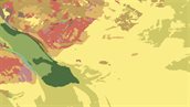
New overview map
The new geological map of the Kingdom of the Netherlands is available. The new map offers a greatly improved image of the mainland, an entirely new representation of the geology of the North Sea, and for the first time includes the Caribbean part of the Kingdom.