
Mount Saint Peter
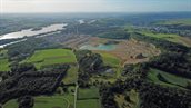
Mount Saint Peter (Sint-Pietersberg) is located south of Maastricht. It became a ‘mountain’ due to the influence of two rivers, the Meuse and the Jeker, which have eroded away its sides. It is known for its marl caves, which were carved out of the rock for marl extraction. The former ENCI quarry offers plenty to see, such as the limestone (referred to as marl (‘mergel’) in Limburg), the original type location of the Maastrichtian age, and much more.
To see in the ENCI quarry at Mount Saint Peter
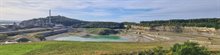
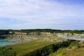
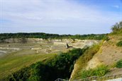
For decades, limestone was mined from the ENCI quarry for the cement industry. The viewing platform on the Luikerweg, which hovers tens of metres above the marl quarry, offers a good overview of the area. Go down the stairs’ 215 steps and stroll through the quarry. At the ENCI quarry’s entrance next to the factory buildings, you will find an important geological monument. The white and yellow limestone with flint layers that you see here was used to name the globally recognised geological age: the Maastrichtian.
To do at Mount Saint Peter
Natuurmonumenten (the Dutch society for nature conservation) has a mobile visitor centre in the quarry. Various walking and cycling routes have been marked, and you can also book guided tours. Armed with a small rock hammer, safety helmet, and safety goggles, you can also carve into the marl chunks yourself at Châlet d’n Observant. You may even find a fossil from the time of the mosasaurs. On top of Sint Pietersberg (‘Mount Saint Peter’), you can visit Hoeve Lichtenberg and climb the medieval tower for a beautiful view of the Meuse Valley. And if you like wine, visit the Apostelhoeve, a wine estate in the beautiful Jeker Valley. Be sure to also visit the marl caves in Sint Pietersberg (‘Mount Saint Peter’). By the way, hiking is not the only activity you can do here; you can also fish, run, and cycle.
Geology in brief
During the Late Cretaceous, between 71 and 66 million years ago, the area we now know as South Limburg was a subtropical sea. This Cretaceous Sea was teeming with life. The chalk of Sint Pietersberg (‘Mount Saint Peter’) consists almost exclusively of fossils; each grain of limestone is a piece of the remains of an animal or single-celled algae with a calcareous skeleton that lived in the sea.
Geological structure
In the ENCI quarry, you can observe the Formation of Gulpen, with, on top of it, the Formation of Maastricht, which can be recognised by its yellower colour and on average smaller flint nodules. If you look closely, you can observe a layer of fine-grained sand from the Oligocene on top of the Sint Pietersberg (‘Mount Saint Peter’) plateau, followed by coarse sand and gravel from the river Meuse. In the centre of the plateau, there are still places with 5 metres of loess from the ice ages.