
Geologisch veldonderzoek
Over the past 100 years, a lot of research has been done in the Netherlands on the structure of our subsurface. We deploy various techniques or a combination of them depending on the question to be answered. This includes drilling, probing, seismic research, and tTEM.
Filling up gaps in the data
A lot of geological information is already accessible via the DINO database, and with the advent of BRO, the amount of available data will continue increasing. But even with hundreds of thousands of drillings having been conducted, there are still ‘gaps’ in the available data. From some sites, for example, the right samples or analyses were not taken. In other cases, the available data are too shallow or of too low (both vertical and horizontal) resolution. Or they are not of the right type, since line or planar data are needed and point data alone do not suffice. In such cases, we set up new field research, both for external clients and from our own information task.
Drillings and cone pressure tests
Geology is hidden beneath our feet. To view, describe, and interpret it, we carry out manual and mechanical drillings. This gives us a glimpse into the subsurface, from several centimetres to hundreds of metres deep. In our Sediment Characterisation Room, we describe the samples in detail to capture as many features as possible. These comprehensive descriptions are the ‘golden nails’ we use to better interpret other drillings and data. In this, borehole measurements that are often carried out in deeper boreholes help to visualise the structure and composition even better.
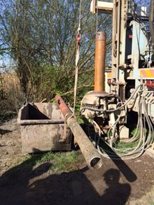
CPTs are often conducted in preparation of drillings to select the best drilling location or to support geological interpretations along transects. To carry out mechanical drillings, CPTs, and borehole measurements, we have fixed partnerships with various parties.
Grain size, geochemistry, and permeability
Sometimes, it is necessary to take measurements of drill samples to determine subsurface properties in even greater detail. After the description, we take samples of, for example, the grain size or geochemical composition of the material. For the analytical work, we have fixed partnerships with other laboratories.
A special case is the determination of sediment permeability. For sandy material, we have our own Hydraulic Conductivity Lab where we can measure our own samples. We have clayey material analysed at other laboratories. We also have a Palynological Laboratory where we prepare sediment and rock samples for analysis by our experts.
Great detail using 2D and 3D
Sometimes, point information obtained by drillings and/or CPTs alone is insufficient to map a complex subsurface. Instead of placing a lot of boreholes or CPTs at short intervals, in such instances, it is better to use 2D (line) or 3D (planar) techniques. Combining them with point information (1D) allows us to map out the subsurface in great detail and high quality. The different techniques can also be combined by performing them sequentially in the field for a wider depth range.
Ground radar
Ground radar, also known as geo-radar or ground-penetrating radar (GPR), is a geophysical technique that is well suited to map the upper 10 metres of the subsurface. The technique is ideally suited for sandy soils with deeper groundwater levels because it can penetrate this material well. This is in contrast to clay and shallow groundwater, which both dampen the signal.
GPR data can be collected by dragging antennas over the earth’s surface, usually with a cart. These carts are so light that they leave no trace on the landscape (non-destructive). The antennas transmit electromagnetic pulses, which are reflected at layer transitions in the subsurface, which they then capture. The results are mostly 2D profiles of the subsurface, but 3D is also possible.
tTEM
The towed transient electromagnetic system (tTEM) is the latest addition to the field techniques we can deploy to map the subsurface up to a depth of about 60 metres. The line information it generates makes it possible to map the subsurface between point data (such as drillings or CPTs) or as preparation to select the most suitable sites. Read more about tTEM in this news item.
Seismic research
For a better picture of the deeper subsurface in particular, seismic surveys are a widely used method. Seismic waves, caused by vibrations of natural or human origin, travel through the earth. By detecting and processing reflections from those waves, among other things, a clear image of the subsurface can be formed. Geophones are usually used to find the waves. A new development in this field is the detection of seismic waves through fibreglass, with kilometres of fibreglass cables acting as sensors.
With our seismic array of geophones, optionally supplemented by fibreglass cables, we can collect subsurface information over a wide depth range, ranging from tens of metres to several kilometres deep. Working with fibreglass cables allows for improved sensitivity and accuracy at depth and makes it easier to extend the sensor network.
At TNO, we develop and use different ways of conducting seismic research for various purposes. An example is our research into passive seismic surveying, using the Earth’s background noise to create an image of the subsurface or changes in it. This means we do not generate vibrations ourselves. We are also working to innovate existing methods in active seismic research, mostly focusing on improving resolution in the shallow subsurface range.
Monitoring and measuring geothermal energy
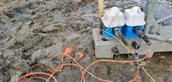
A geothermal doublet pumps hot water from the deep subsurface, extracts the heat, and re-injects the cold water. Because the water is salty and hot (70-100˚C) and contains dissolved gas, special techniques exist to monitor and sample it.
Gas and water samples can be taken directly from the system by connecting a so-called autoclave, a stainless steel barrel, to the geothermal system. As a result, dissolved gas cannot escape and oxygen cannot be added, allowing for better analyses in the lab.
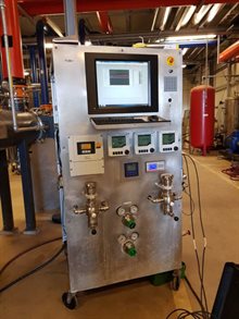
Working with European partners such as GFZ Potsdam, we also connected a monitoring device (‘FluMo’) to a geothermal plant. This device enables real-time insight into, for example, acidity changes accompanying temperature and pressure fluctuations in the system. With these accurate and reliable data, we can better help operators tackle corrosion and precipitation (scaling).
More information.
-

Ronald Harting
Functie:Geologist/Fieldwork coordinatorSpecialisatie niet bekend-
Telefoon:+31 88 866 48 24
-
E-mail:E-mail Ronald
-