tTEM: new technology provides quick insight into subsurface structure
For groundwater management and many subsurface-related issues, it is important to know the distribution of clay and sand layers in the subsurface. Insight into the quality of groundwater, such as its salinity, is also important in large parts of our country. Recently, the Geological Survey of the Netherlands (GDN), which is part of TNO, started using a new measuring instrument. The new instrument, tTEM, is towed by a quad and takes measurements that create a detailed, three-dimensional image of the distribution of layers of clay and sand, as well as saline groundwater. The province of Drenthe was the first to put the device to use.
The new technology is especially relevant for agricultural areas, on dirt roads, and in nature reserves. It supplements the current technique of collecting subsurface data using boreholes and CPTs, amongst others. Preceded only by Denmark and the United States, this is the Netherlands’ first tTEM device. For GDN, the Netherlands’ foremost subsurface-related knowledge and research centre, tTEM is a valuable addition to its existing techniques. ‘This device allows us to map out the subsurface in detail. The tTEM measurements, combined with existing knowledge and models of the subsurface (Grondwaterkwaliteitinbeeld.nl, REGIS II, GeoTOP), provide a highly accurate three-dimensional estimate of the structure and properties of the subsurface’, explains GDN geologist, Jan Gunnink.
Insight into the complexity of the subsurface
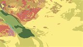
The composition of the subsurface is important to a wide range of geotechnical and hydrological applications. For example, knowledge about the location and continuity of clay layers in the upper 60 metres is often crucial when designing targeted measures. Consider, for instance, clay layers near dykes (piping) and the spread of pollutants to deeper layers through holes in the clay layers. The new technology is an efficient method to 3D map the subsurface up to depths of 60 metres. In the Netherlands, the first measurements were taken in the province of Drenthe, in the Drentsche Aa area. The results are generating new insights into the presence and continuity of clay layers.
tTEM in the future
Technology never stands still. For example, the tTEM device can also make measurements on inland waterways when towed by a boat. Doing so allows us to map out the subsurface under inland waterways, which to date are parts of the subsurface for which limited data are available. We can also collect data on the outside of dykes, enabling us to better predict the subsurface beneath the dykes.
Curious what tTEM can do for you?
We have created a leaflet (pdf, 1.4 MB) (only available in Dutch) to provide more information on how the tTEM device functions. If you have any questions after reading this page or the leaflet, or if you would like to find out how tTEM can help you, please contact Jan Gunnink.
Interested in more information?
-

Jan Gunnink
Functie:GeologistSpecialisatie niet bekend-
Telefoon:+31 88 866 49 10
-
E-mail:E-mail Jan
-