Updated seabed-sediment map provides more insight into the seabed of the Dutch North Sea
The North Sea is playing an increasingly important role in addressing major societal challenges including energy production, ecosystem restoration and infrastructure development. These challenges are driving a more intensive and multifunctional use of the North Sea, where activities such as offshore wind energy production, shipping, fishing, nature conservation and subsea infrastructures are increasingly overlapping and interacting within the same marine space.
Effective and sustainable integrating these activities requires a sound understanding of the seabed and subsurface. The composition of the seabed is particular important, as it influences, for example, the distribution and establishment of marine organisms on the seabed and determines the suitability of locations for interventions such as ecosystem restoration measures.
Using geo-data to restore the biodiversity in the North Sea
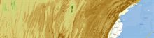
The seabed-sediment map of the Dutch sector of the North Sea visualises the composition of the seabed. Developed and recently updated by TNO Geological Survey of the Netherlands, the map offers detailed representation of the upper half metre of the Dutch North Sea seabed.
The seabed-sediment map has been revised and now includes a new feature: the mud-percentage map. In addition, updated bathymetric data (measurements of seabed depth) have been incorporated, and the map coverage has been extended to include the entire Dutch North Sea area up to the coastline. Together, these improvements offer a more comprehensive, detailed and accurate depiction of seabed composition, including the proportions of mud, sand and gravel.
Supporting policy and sustainable use of the Dutch North Sea
This information provides an essential foundation for a wide range of applications, including ecological habitat suitability assessments, the technical planning of cables, pipelines and sand extraction activities. As such, the seabed-sediment map offers a scientific basis for stakeholders operating on or interacting with the seabed, and supports policy development, environmental protection and the sustainable use of the North Sea.
The update of the seabed-sediment map was commissioned by the Ministry of Agriculture, Fisheries, Food Security and Nature (LVVN) and forms part of the implementation of the European Nature Restoration Regulation.
Strategic guidance for a shared North Sea
According to Joris Koornneef, Mayor of Your North Sea, the updated seabed-sediment map represents an important step forward:
“The new data makes it possible to better align the role of the North Sea in future planning across sectors such as energy, safety, nature and food production,” says Koornneef.
Koornneef continues: “The updated seabed-sediment map provides essential information about the upper layer of the seabed at a level of detail that was previously unavailable. This supports professionals in making well-informed decisions in the North Sea area, where space is limited and multiple functions converge. The map is also relevant for coastal municipalities, for example when addressing questions related to cable landfalls or local sand extraction.”
New data and mud-percentage map
The update of the seabed-sediment map includes several improvements. The Dutch coastline is now fully covered through the integration of new datasets, and a new feature has been added: the mud-percentage map.
The mud-percentage map provides detailed information on the mud content at specific locations. This is particular valuable information for organisations such as Deltares and Wageningen Marine Research, as the mud content of the seabed is a key factor determining whether shellfish species such as the European flat oyster, blue mussel and horse mussel can successfully establish and thrive in a given area.
These shellfish species play a central role in the North Sea biodiversity. Within the framework of the European Nature Restoration Regulation, the Netherlands is required to identify areas where the restoration or re-establishment of habitats for these species is feasible. The new map data offer a scientific basis for identifying locations where restoration measures are likely to be most effective. The data have already been incorporated into habitat-suitability maps developed by Deltares for the shellfish species mentioned above.
Field data provide a more detailed view of the seabed
The integration of up-to-date field data has enabled the revised seabed-sediment map to achieve an unprecedented level of detail. This enhanced view is the result of combining decades of seabed mapping conducted by TNO Geological Survey of the Netherlands with publicly available datasets from Rijkswaterstaat as well as information derived from recent seabed samples collected by the offshore wind and sand-extraction sectors. This integration of historical and contemporary datasets provides a robust scientific foundation for the sustainable spatial planning and management of the North Sea.
“For the development of offshore wind farms in the North Sea, this is a major win-win situation. The newly added field data, including seabed samples, enrich our understanding of the North Sea as a whole. This knowledge will also help inform future decisions on suitable locations for offshore wind farms,” says Koornneef.
View the map
The updated seabed-sediment map is available through DINOloket, where users can also access accompanying documentation describing the methodologies employed and the various map layers included.
Go directly to the updated seabed-sediment map
Read more about the seabed-sediment map and methodology
The map is also available through the Marine Information and Data Centre (Informatiehuis Marien).
More information?
-

Willem Dabekaussen
Functie:GeologistSpecialisatie niet bekend-
E-mail:E-mail Willem
-
-

Joanne Erkelens
Functie:Communication advisorSpecialisatie niet bekend-
E-mail:E-mail Joanne
-