
Subsurface modelling as part of GDN’s statutory task
The Geological Survey of the Netherlands (GDN) has the statutory task of creating and managing subsurface models, based on the information provided through the National Key Registry of the Subsurface (BRO). These models make knowledge of the subsurface available to users.
Our statutory task of subsurface modelling uses the data GDN manages in line with the National Key Registry of the Subsurface Act. We publish these models via BROloket.
Use our 3D models via BROloket
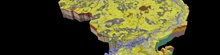
BRO GeoTOP
We are expanding our most shallow model, GeoTOP, one region at a time. In doing so, we are working in consultation with the Ministry of the Interior and Kingdom Relations (BZK) and the Ministry of Economic Affairs and Climate Policy (EZK). Every two to three years, a region (including its geological knowledge) is added to the model. Regions already featured in the model are the west of the Netherlands, North Brabant, and North and Central Limburg.
BRO DGM
DGM is a 3D layer model that represents the subsurface of the Netherlands up to approximately 500 metres below sea level, in blocks of 100 x 100 metres. There are also outliers in DGM of up to around 1,200 metres. The model shows the lithostratigraphic layers in the subsurface and the formations to which the layers belong.
BRO REGIS II
The 3D layer model, REGIS II, also shows the subsurface of the Netherlands up to approximately 500 metres below sea level, in blocks of 100 x 100 metres. REGIS II also has outliers up to a depth of around 1,200 metres. The model shows which are the layers of high and low permeability in the subsurface. These layers are called hydrogeological units and have more or less uniform hydraulic properties.
Read more about our models GeoTOP, REGIS II and DGM
More information.
-

Denise Maljers
Functie:Research ManagerSpecialisatie niet bekend-
Telefoon:+31 6 21 33 57 64
-
E-mail:E-mail Denise
-