New geological map of the Kingdom of the Netherlands
The new geological map of the Kingdom of the Netherlands is available. The state of knowledge of the Dutch subsurface is summarised by the Geological Survey of the Netherlands (GDN) in an overview map that is only released once every few decades. The last geological map dates from 1975.
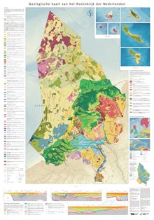
Geological map of the Netherlands
The new paper map offers a greatly improved image of the mainland, an entirely new representation of the geology of the North Sea, and for the first time includes the Caribbean part of the kingdom. The map shows which deposits make up the upper metres of the subsurface. The map units represent (combinations of) formations (Fm), members (Lp), and layers. Holocene members occur stacked in the coastal zone. These stacks are defined as profile types, mapped separately, and identified by lower-case codes.
The 2023 geological map has a map scale of 1:600,000. The map is based on a multitude of published data, supplemented with recent information and insights. For the Dutch mainland, this mainly involves information collected as part of the 1:50,000 geological mapping (approx. 1950-1997) and the creation of the 3D subsurface models DGM and GeoTOP (1997-present).
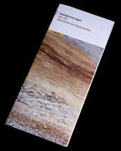
Order the geological map of the Netherlands
The folded paper geological map of the Netherlands costs €15 (including VAT and excluding shipping costs) and is available to order from GDN’s web shop.
The PDF document of the overview map (pdf, 23 MB) is available for free, and the digital version can be found on DINOloket.
More information?
-

Servicedesk
Functie niet bekendSpecialisatie niet bekend-
Telefoon:+31 88 866 43 00
-
E-mail:E-mail Servicedesk
-