
Cycling route ‘Utrechtse Heuvelrug and Kromme Rijn’
This excursion is part of a series of geological walking and cycling routes of the Geological Survey of the Netherlands (GDN). Through these routes, GDN aims to introduce you to the Dutch subsurface and its influence on the present-day landscape in an accessible way.
The route description starts with a general introduction. This description will give you a quick explanation of the formation of the landscape as you encounter it while cycling. Then the route starts. You’ll pass 13 so-called ‘stopping points’ along the way. At these ‘stopping points’, you are invited to take a closer look at the landscape or sediment using the route’s explanatory notes. This cycling tour includes a detachable map. This map contains practical information, such as cycling nodes, places of interest, and a selection of catering establishments enroute.
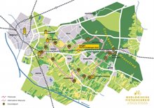
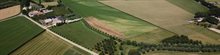
Visualization of the cycling tour
Availability
The geological cycling tour is not sold by the Geological Survey of the Netherlands. Sale points are (among others):
- Wijk bij Duurstede Tourist Office (VVV), Markt 24, 3961 BC Wijk bij Duurstede
- Houten Tourist Office (VVV), Onderdoor 80, 3995 DX Houten
Downloads
Download PDF directions (pdf, 4.6 MB) only available in Dutch
Download PDF roadmap (pdf, 3.2 MB) only available in Dutch
Download GPX version of the route (zip, 13 kB)
Download KML version of the route (zip, 12 kB)