
H3O-De Voorkempen Project
The H3O-De Voorkempen Project is one of the projects covered by the H3O programme. The name of the project derives from the Belgian region De Voorkempen. The project focuses on the (hydro)geological mapping of the subsurface of the border area between West Brabant (the Netherlands) and De Voorkempen (Belgium). The H3O-De Voorkempen model area is connected along its eastern side to the model area of the H3O-De Kempen Project, which was completed in 2018.
Results
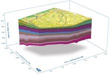
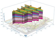
In collaboration with Dutch and Belgian partners, a (hydro)geological 3D subsurface model of the relevant border area was also created within the H3O project. The 3D model H3O-De Voorkempen shows the clastic deposits of the Cenozoic era (the geological period between 66 million years ago and the present), including rock layer deposits from the Quaternary, Neogene, and Paleogene periods. A new feature of this project is that previously defined units have been interpreted and modelled on a regional scale for the first time.
The project differs from already completed H3O projects in several ways. The collaboration partners deliberately chose a new working method and project approach to determine whether (and to what extent) the future-oriented and sustainable alignment of the national reference models is feasible.
New working method and project approach
Country-specific (hydro)geological classifications were followed in data interpretation and modelling. In addition, shallow modelling was carried out for each sub-area using existing methods from project partners VITO and GDN. This unique combination of methods (drilling data and seismic data), as well as data differing in detail and interpretation from one country to another, has resulted in a single (hydro)geological 3D model that meets both Dutch and Belgian requirements. This is partly due to the outstanding collaboration between all partners.
Completion of H3O-De Voorkempen Project
The H3O-De Voorkempen project started on 17 February 2020 and was concluded with a webinar on 28 September 2023 and a field trip to the border region on 29 September. The results were presented during the webinar ‘H3O-De Voorkempen: new insights into and applications of inter-regional subsurface models’ and are available digitally via DINOloket. This successfully completes the fifth project within the H3O programme.
 |
 |
|---|
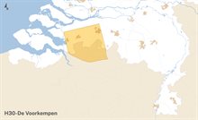
Model area project H3O-De Voorkempen
Collaboration partners
The Geological Survey of the Netherlands (GDN) is collaborating with the following partners in the H3O-De Voorkempen Project:
The Netherlands
Belgium
More information.
-

Ronald Vernes
Functie:Programme Manager Local GovernmentSpecialisatie niet bekend-
Telefoon:+31 88 866 47 80
-
E-mail:E-mail Ronald
-